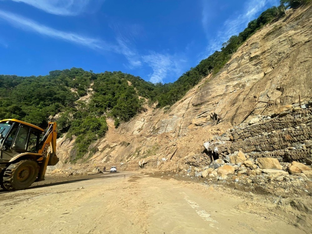
An excavator clears debris and smoothens the roads in the landslide-, rockfall-, and soil erosion-affected Chainage 126 section of the Tsiedukhru Range stretch of National Highway H-29 on September 28. The NH-29 four-lane, as well as other road construction works in Nagaland, have been affected by various natural challenges. Among others, experts have called for a dedicated State Landslide Policy to address these challenges. (Morung Photo)
Atono Tsükrü Kense
Kohima | September 29
Hazard mapping, slope reinforcement, and a dedicated State Landslide Policy are among the steps experts believe Nagaland must urgently adopt to make its roads safer.
With the State’s fragile geology and intense rainfall leaving infrastructure constantly at risk, geologists caution that mitigation cannot remain an afterthought. But how safe are the roads we travel on today?
In the second part of The Morung Express series on landslides, geologists David Lhoupenyi and Dr Temsulemba Walling, who have been closely studying slope failures across Nagaland, share their insights on road safety, possible solutions, the need for proper hazard mapping, and the urgent steps the government must take.
How safe are our roads?
“Our roads are not entirely unsafe,” Lhoupenyi held, “but in young mountains like Nagaland, we are bound to pass through more weak or landslide-prone sections. Without proper measures, the risks are always present.”
Dr Walling agreed that the situation remains precarious, noting that hazardous events can happen anywhere, anytime, to anybody, and one has to accept that the State is combating “unique and unfavourable geology.”
Despite the huge efforts from several quarters, he added, “We are still largely at the mercy of nature.”
Both emphasised that detailed scientific investigations should be carried out to identify and outline susceptible zones and develop remedial mitigative measures to prevent and minimise loss of life and property.
Workable measures?
Landslides are not one-size-fits-all problems, and remedial measures can be reasonably recommended after diagnosing the cause of the problem, said the geologists.
While landslides occur due to a combination of several predisposing factors and triggers, the duo emphasised that remedial measures must be tailored to the type of landslide.
Slope modification, surface and sub-surface drainage, retaining structure techniques, slope reinforcement techniques, berming, check dams, rock bolting, shotcreting, rockfall nets, grouting, bioengineering interventions, tunnelling, etc., were listed as some effective options.
Besides, the experts also underlined the importance of monitoring and early warning systems in high-risk areas.
Mapping the risks
So, does Nagaland have a detailed landslide hazard map? The answer, both geologists concurred, is complicated.
“Yes and no,” replied Lhoupenyi, a Geologist at the Directorate of Geology & Mining (DGM) Nagaland.
Validating his point, he said that the Geological Survey of India (GSI), as well as the Directorate of DGM and Nagaland University (NU), had undertaken landslide susceptibility mapping of Nagaland at the Meso-scale and also along the road sections of various National Highways in Nagaland and Kohima Town.
However, he pointed out that the above studies are not sufficient for planning road and building projects, as macro or large-scale mapping is required for practical planning.
Besides, the DGM geologist added that in road and building projects, there is no fund provision for any systematic landslide mitigation apart from conventional retaining walls and some piling.
Meanwhile, NU Associate Professor Dr Walling informed that GSI mapped Nagaland at a 1:50,000 scale under the National Landslide Susceptibility Mapping programme and is currently preparing mesoscale 1:10,000 scale maps for priority road corridors, expected by 2030.
While the Environmental Impact Assessment (EIA), including geological investigations, is a prerequisite for major developmental projects, and the guidelines and standards for highway construction by the Indian Road Congress (IRC) exist, he remarked, “Whether these parameters are fulfilled or not during the implementation of different projects, I am not aware.”
Development Vs Safety
While balancing infrastructure growth with slope safety is one of Nagaland’s toughest challenges, Lhoupenyi asserted that mega-projects should not be allowed without detailed geological and geotechnical investigations for suitable slope mitigation measures.
Dr Walling called for context-sensitive solutions, suggesting the use of light structures with strong foundations and proper drainage, such as bamboo and other local materials, which put less strain on fragile slopes.
“Until a technological breakthrough tailored to our terrain and geology is achieved, and we also come up with landslide-resistant structures, we should strive for what is compatible with our soil and foundation,” he added.
He further reiterated the need for proper geological investigations and foundation engineering for all developmental activities, avoiding landslide-susceptible areas.
The policy gap
Both experts pointed to a critical missing link a State Landslide Policy, which could govern mega-projects, support landslide investigations, and their mitigation with systematic funding across various allied departments.
“Lack of a Landslide Policy in a landslide-prone State like Nagaland is a major setback, where mitigation is done without proper detailed landslide investigations funded by random sources,” maintained Lhoupenyi.
Lack of data sharing (databases of landslide studies) held by individual agencies results in less coordination and limited collaboration among the scientific community, he added.
“There appears to be a lacuna as far as coordination and data sharing are concerned,” averred Dr Walling.
Way forward
For Lhoupenyi, the priority is clear: a ‘State Landslide Policy’ that governs major human activities, geological investigation for proper and suitable remedial measures, linked with systematic government funding.
Dr Walling calls for the formation of a ‘Scientific Advisory Committee or Expert Panel’ with regular consultative meetings and brainstorming sessions to prepare a roadmap and strategies.
Besides, he suggested roping in and utilising multidisciplinary experts familiar with the local geology and working in the area, while highlighting that several individuals are already working in this field in Nagaland.
He also emphasised the need to indigenously develop and install early warning systems using a combination of remote sensing, automatic weather stations, data loggers, geotechnical data, and Artificial Intelligence, until the Satellite Integrated Landslide Assessment and Alert System (SILAAS) programme becomes operational in Nagaland.
The professor also advocated for public awareness as well as detailed case studies in identified critical areas, employing various geotechnical, seismological, resistivity, InSAR, Lidar, optical remote sensing, modelling and simulation, and machine learning techniques.
This is the second and final part of a two-part series on landslides in Nagaland.
Read the Part-I here:
WHEN THE HILLS COLLAPSE: Understanding Nagaland’s landslide crisis
https://www.morungexpress.com/when-the-hills-collapse-understanding-nagalands-landslide-crisis