Morung Express News
Dimapur | October 24
Nagaland and other Northeastern states are likely to isolated experience heavy rainfall and thunderstorms over the coming days as a depression over the Bay of Bengal is forecast to intensify into a very severe cyclonic storm and move towards the Andhra Pradesh coast, according to the India Meteorological Department (IMD).
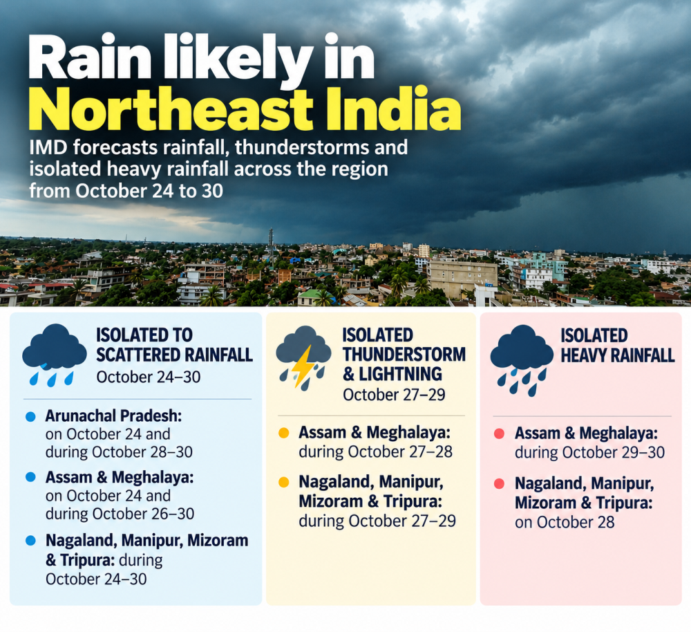
In its October 24 night bulletin, the IMD forecast isolated heavy rainfall in Nagaland, Manipur, Mizoram and Tripura on October 28. It further forecast isolated to scattered rainfall in the four states from October 24 to 30, with isolated thunderstorms and lightning likely from October 27 to 29.
Assam and Meghalaya are also likely to receive isolated to scattered rainfall from October 26 to 30, with isolated thunderstorms and lightning forecast on October 27 and 28. Isolated heavy rainfall is likely in the two states on October 29 and 30. Arunachal Pradesh is forecast to receive isolated to scattered rainfall from October 28 to 30.
Depression likely to intensify into very severe cyclonic storm
The forecast comes as a depression over the east-central and adjoining southeast Bay of Bengal, centred near latitude 15.8°N and longitude 90.7°E at 5:30 pm on October 24, is expected to intensify further.
The system was located about 820 km east-southeast of Visakhapatnam in Andhra Pradesh, according to the IMD.
The depression is very likely to intensify into a deep depression on October 25 before developing into a cyclonic storm over the east-central and adjoining west-central Bay of Bengal by the morning of October 26. It is then expected to strengthen into a severe cyclonic storm around the morning of October 27 and a very severe cyclonic storm by the morning of October 28.
Moving northwestwards, the system is likely to reach the west-central Bay of Bengal near the Andhra Pradesh coast around the morning of October 28. It is very likely to cross the Andhra Pradesh and Yanam coasts between Bapatla and Visakhapatnam by the forenoon of October 28, with maximum sustained wind speeds of 115–125 kmph and gusts reaching 140 kmph.
Heavy rainfall, gale-force winds and rough seas expected
The IMD has forecast heavy to very heavy rainfall, with isolated extremely heavy rainfall, over coastal Andhra Pradesh on October 27 and 28. Odisha is likely to experience heavy to very heavy rainfall on October 27 and 29, with isolated extremely heavy rainfall on October 28. Telangana is also likely to receive heavy to very heavy rainfall, with isolated extremely heavy rainfall, on October 28.
Fairly widespread to widespread rainfall is forecast over Odisha from October 27 to 30, Bihar and Jharkhand from October 28 to 30, and parts of West Bengal and Sikkim during the latter part of the week.
The IMD has forecast increasingly rough sea conditions and strong winds over the Bay of Bengal as the system intensifies. Squally weather, with wind speeds of 40–50 kmph and gusts up to 60 kmph, was forecast over the east-central and adjoining southeast Bay of Bengal and along and off the Andaman Islands on October 24. Wind speeds are expected to rise to 50–60 kmph, gusting to 70 kmph, on October 25.
Gale-force winds exceeding 70–80 kmph, with gusts up to 90 kmph, are forecast over the west-central and adjoining east-central Bay of Bengal by the morning of October 26, with winds likely to strengthen further as the system moves northwestwards.
Sea conditions are expected to become high to very high over the west-central and adjoining east-central and northwest Bay of Bengal from October 26 to 28. Conditions along and off the Andhra Pradesh and Odisha coasts are likely to remain rough to very rough during October 27 and 28.
IMD advisories
The IMD has advised fishermen to return to the coast by the morning of October 24 and not venture into the east-central and adjoining southeast Bay of Bengal until October 26. They have also been advised to avoid the west-central and adjoining northwest and southwest Bay of Bengal from October 26 to 28, as well as areas along and off the Andhra Pradesh and Odisha coasts from October 27 to 28.
Separately, a low-pressure area over the southeast Arabian Sea and adjoining Lakshadweep region persisted on October 24. The associated system is expected to bring isolated extremely heavy rainfall over Tamil Nadu, Puducherry and Karaikal on October 24–26, and Kerala and Mahe on October 25–26.
The IMD reported that extremely heavy rainfall had already been recorded in Tamil Nadu in the 24 hours ending at 8:30 am on October 24. Very heavy rainfall was recorded in Kerala, while Goa and Karnataka received heavy rainfall.
The IMD has advised people to keep track of weather updates and be prepared for deteriorating conditions where heavy rainfall and strong winds are forecast. It has also cautioned that heavy rain and strong winds may cause tree branches to break, damage vulnerable structures and crops, affect road and rail traffic, and trigger localised waterlogging, flooding and landslides in susceptible areas.